Ride Stats
Distance: 56km | Elevation: 675m | Ride time: 2–3 hours | Difficulty: Moderate | Surface: Tarmac
Quick Answer
The shortest route in the Wild West Coast set and the most iconic. From Sagres fortress west to the Cabo de São Vicente lighthouse — the most south-westerly point of mainland Europe, with cliffs dropping into the Atlantic on three sides. 56km, 675m, and a lighthouse at the edge of the continent as the turnaround. Wind direction determines which leg is harder — check the forecast before setting out.
Quick Overview
- The Headland: West from Sagres to Cabo de São Vicente — the most south-westerly point of mainland Europe, cliffs dropping into deep water on both sides throughout
- Stop — Picnic Sagres: Specialty coffee, sourdough, and homemade pastries in Sagres — the pre-ride stop before heading to the lighthouse headland
- The Lighthouse: Cabo de São Vicente — sheer Atlantic cliffs, a Volta ao Algarve stage finish, and the genuine sensation of being at the edge of the continent. Take a moment
- Wind: The Atlantic north-westerly is the defining variable — it can make a short ride feel considerably harder than the numbers suggest. Check the forecast before choosing your direction
- Post-Ride — Santo Loco (Sagres): Relaxed café and surf shop in Sagres — the natural post-ride stop with good coffee and a welcoming atmosphere on the return
- Best season: Year-round — the lighthouse is dramatic in all weather. Summer mornings are the calmest window before the north-westerly builds
The Lighthouse at the Edge of the Continent
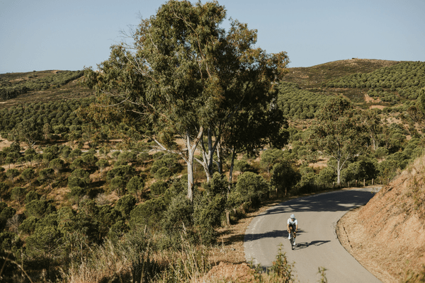
Land’s End is the shortest of the Wild West Coast routes and the most memorable. From Sagres the road runs west across the headland to the Cabo de São Vicente lighthouse — 56km round trip on exposed Atlantic cliff roads with nothing between the rocks below and the Americas.
At 675m of elevation it is the most accessible day in the Wild West Coast set. The exposure is what makes it. The wind off the open ocean is rarely absent. The scale of the cliffs below the lighthouse is something photographs do not quite capture. This is the ride that most visitors to Sagres do once and think about for years afterwards.
Route Profile
From Sagres fortress the road heads west across the headland — flat to rolling on exposed terrain with the Atlantic visible on both sides at the narrowest point.
Pre-Ride — Picnic Sagres
Specialty coffee, sourdough, homemade pastries, and bagels in Sagres. Open from early morning and the right pre-ride stop before heading to the lighthouse. The sourdough bagels are a local favourite and the coffee is among the best in the western Algarve.
The Headland Road
West from Sagres the road runs across the exposed headland. The gradient is gentle throughout but the wind is the variable that determines how the legs feel. The Atlantic is visible on both sides in the narrowest section before the lighthouse appears ahead.
Cabo de São Vicente
The lighthouse at Cabo de São Vicente sits on cliffs that drop into the Atlantic. The wind here is almost always present and can be strong — the headland is one of the most exposed points in Portugal. Take time at the lighthouse. The scale of the sea below and the emptiness of the horizon are part of what makes this the ride that stays with people. Then turn around.
Post-Ride — Santo Loco (Sagres)
Santo Loco is a cozy café and surf shop near the popular routes in Sagres — good food, good coffee, and a relaxed post-ride atmosphere. The natural place to sit outside and decompress after the headland loop.
What You Will Need
- Two bottles — the headland is short but exposed and dehydration is faster than the distance suggests
- Two gels — even a short exposed day benefits from on-bike nutrition
- A gilet in winter — the Atlantic wind chill on the headland is significant in February and March regardless of the air temperature in Sagres
- A wind forecast check — direction shapes the effort on both legs of this ride
Best Time to Ride
Year-round. The lighthouse is dramatic in all weather — fog, wind, and clear days each deliver something different. In summer the early morning is the calmest window before the north-westerly builds. In winter the headland is raw and the light at the lighthouse is genuinely unlike anywhere else.
Book the Bike. We Will Handle the Rest.
The lighthouse at the edge of the continent. Your Cervélo Soloist delivered to Sagres, Salema, or Aljezur — pre-fitted, pre-loaded with the route, and ready to ride.
Book your bike with Velo Algarve →
Frequently Asked Questions
Is the Cabo de São Vicente route safe in strong wind?
The road is tarmac and well-maintained. In very strong winds the exposed headland section requires focus and a lower gear. Most riders manage it comfortably. In exceptional storm conditions — which are rare but occur in winter — the road can be unpleasant. Check the forecast and apply judgement.
How long does Land’s End take?
56km and 675m of elevation. Most fit road cyclists allow 2 to 3 hours at a comfortable pace including the stop at the lighthouse. Factor in the wind — the north-westerly on the exposed headland adds effort that does not show in the elevation numbers. See our FAQ page for more on planning your riding days.
Is this route suitable for a first day or a recovery day?
Yes to both. At 56km it is the most accessible Wild West Coast day and works well as an opener when the legs are fresh or as a lighter day between harder efforts. The wind is the only variable that can make it harder than the numbers suggest.
Can I combine Land’s End with the other Wild West Coast routes in the same week?
Yes — and that is the natural Wild West Coast week. Land’s End as the accessible day, The Protected Coast for the natural park roads north to Carrapateira, and Lighthouse to Lagos for the full coastal connection east. Three completely different days from the same Sagres base.
Which Wild West Coast base gives the best access to this route?
Sagres is the most direct — the lighthouse is 15km from the fortress. Salema adds a short approach via Vila do Bispo. Aljezur requires the longest approach but gives the most remote version of the day. All three are Wild West Coast bases with bikes delivered to the door.
No Comments