Quick Answer: The best hiking in the Algarve includes the Seven Hanging Valleys Trail, the Fishermen’s Trail near Sagres, the Foia summit circuit in Monchique, and the coastal walks around Lagos. October through April is the best time to hike thanks to cooler temperatures and clearer trail conditions. The Algarve has a hiking problem. Not a shortage of trails – the opposite. There are so many signposted routes, long-distance paths, cliff walks, and mountain circuits that deciding where to actually go can eat up time you should be spending outside.This guide cuts through that. It covers the best hikes in the Algarve from every corner of the region – western coast to eastern lagoons, Atlantic cliffs to the Monchique highlands – with the kind of detail that actually helps you choose: distances, elevation, where to start, what the terrain is like, and when to go.Whether you are here for a week and want two or three genuinely good days on foot, or you are planning a longer stay with hiking as the main event, this is where to start.
Key Takeaways
- The best hiking in the Algarve is concentrated in three areas: the western Atlantic clifftops from Lagos to Sagres, the Serra de Monchique, and the Ria Formosa lagoons near Faro and Olhão.
- The Seven Hanging Valleys trail near Praia da Marinha is the single most photogenic route in the region and a genuine half-day hike rather than a tourist walk.
- October to April is the main season. Summer hiking is possible but plan for early starts and carry water.
- The Fishermen’s Trail from Luz to Sagres is 35-40 km of clifftop walking, splittable into two or three days.
- The Via Algarviana covers 300 km of inland mountain terrain – individual stages are accessible as day hikes from Monchique, Alte, and Salir.
- The Foia summit circuit from Monchique is the region’s most rewarding mountain hike: 12-15 km, 700 m of ascent, views across the entire Algarve from 902 m.
- Velo Algarve delivers premium carbon road bikes to your accommodation anywhere in the Algarve, making it easy to add a road ride to your hiking trip.
The Best Hiking Trails in the Algarve
Start with these Algarve hiking trails if you want the biggest payoff for your time, from dramatic clifftop routes to inland mountain climbs with proper views.
1. The Seven Hanging Valleys Trail (Percurso dos Sete Vales Suspensos)
Start: Praia da Marinha, near Lagoa
Distance: 11.4 km (linear) or ~6 km one-way to Praia de Vale Centianes
Elevation gain: Moderate – rolling clifftop with some steep descents to coves
Difficulty: Moderate
Best season: October – May
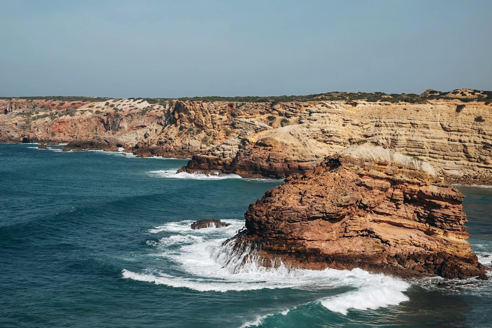
This is the trail that earns the Algarve its reputation for coastal hiking. The path runs along the clifftops between Praia da Marinha and Praia de Vale Centianes, crossing the arched valleys that give it its name – deep sea-carved inlets in golden limestone that you look down into from the cliff edge.
The terrain is not technical, but it is not flat either. There are sections where the path narrows to the cliff edge and drops sharply to coves below. The rock formations here – stacked, layered, amber and ochre in the afternoon light – are unlike anything else on the coast. In spring, the clifftop is covered in wild flowers.
You can see the entrance to Benagil Cave from above on this route, though getting into the cave itself requires a kayak or a boat trip from Benagil beach. Plan the hike out-and-back from Praia da Marinha if you want flexibility, or arrange a lift at the far end. The trail ends near a restaurant at Praia de Vale Centianes, which makes a logical turnaround if you are doing a full day.
Wear proper trail shoes. The limestone gets slippery when wet.
2. Ponta de Piedade and the Lagos Coast Walk
Start: Ponta de Piedade headland, Lagos
Distance: 7 km (Lagos to Praia da Luz, or shorter loops from the headland)
Elevation gain: Low to moderate
Difficulty: Easy to moderate
Best season: Year-round, early morning in summer
The stretch of coastline around Ponta de Piedade – the jagged headland of sea-stacks, arches, and rock towers south of Lagos town – is the most photographed section of the western Algarve coast, and for good reason.
The boardwalk and cliff path from the headland south to Praia do Canavial and then to Luz is a genuine coastal walk rather than a tourist loop. The first section down from the car park to the sea level rock formations requires a steep staircase descent, but once down, the formations at water level are extraordinary – narrow channels, golden arches, sea caves accessible by foot at low tide.
For a longer day, walk north from Ponta de Piedade toward Lagos Marina: it is approximately 4 km on the clifftop path, well marked, with views back along the coast toward Sagres. The Lagos waterfront and the old town walls are 10 minutes from the marina if you want to make an afternoon of it.
Start early in summer. By 10 am the headland is crowded. Before 8 am it is near-empty and the light is better.
Worth knowing if you are staying near Lagos: this is also Brad and Juli’s home coast – the road out to Ponta de Piedade is on the regular Velo Algarve cycling route. If you spend a morning hiking the cliffs and want a different perspective on the same terrain, the coastal road from Lagos toward Sagres on two wheels covers ground that the footpaths don’t.
Details on Velo Algarve road bike rentals – bikes delivered to your door across the region.
3. Foia Summit Circuit, Monchique
Start: Vila de Monchique or Foia summit car park
Distance: 12 – 15 km (various circuits)
Elevation gain: 400 – 700 m depending on start point
Difficulty: Moderate to hard
Best season: October – April
Foia, at 902 m, is the highest point in the Algarve and the only place in the region where you genuinely feel altitude. The summit sits above the tree line and on a clear day the view extends from the Spanish border east to Cape St. Vincent west – the entire region in a single panorama.
The PR4 MCQ circuit from Monchique town to the Foia summit is the recommended route: it avoids the road for most of the ascent and passes through cork oak woodland, arbutus and rhododendron scrub, and open ridge before the final approach to the top. The descent back through the Monchique valley passes springs and old water mills.
This hike has a reputation it slightly does not deserve for being hard. The summit circuit is demanding in the sense that it is not flat – there is real climbing involved – but the trail is well-marked and the gradient is sustained rather than brutal. Anyone who hikes regularly will manage it comfortably.
Do not come up in thick cloud. The summit is often above cloud level in winter, which can be spectacular from the top but means a whiteout on the descent if conditions close in. Check before you leave Monchique.
The Foia ascent is also one of the Algarve’s benchmark cycling climbs – the same road Brad rides regularly as part of a Tuesday loop out of Lagos. If you hike it one day and want to understand why cyclists come here specifically to ride it, the descent from Caldas de Monchique back toward the coast gives a completely different sense of the mountain.
4. The Fishermen’s Trail (Trilho dos Pescadores) – Lagos to Sagres Section
Start: Luz beach, near Lagos, or Salema
Distance: Varies by stage – Luz to Salema is approximately 18 km; Salema to Sagres approximately 16 km
Elevation gain: Moderate throughout
Difficulty: Moderate
Best season: October – May
The Fishermen’s Trail is the coastal section of the Rota Vicentina, Portugal’s long-distance network of walking routes through the Alentejo and Algarve. The Lagos-to-Sagres stages are the best known and most walked sections in the south.
The trail runs directly along the Atlantic clifftops from Praia da Luz southwest through Burgau, Salema, Zavial, and Ingrina to Sagres – roughly 40 km in total if you walk it end-to-end, though most people break it into two or three days.
Many hikers also tackle shorter sections from Lagos to Burgau, Salema, or Sagres, then take an Uber or taxi back to Lagos at the end of the day. The landscape is consistent and impressive throughout: high cliffs above a blue-green Atlantic, undeveloped coastline, almost no development visible from the path, and a near-constant wind off the ocean.
The wildlife here is worth paying attention to. Peregrine falcons nest in the cliffs between Luz and Burgau. White storks pass through in spring and autumn. In calm weather the sea surface between the headlands shows dolphins regularly.
The Luz to Lagos section (approximately 7 km) going the other direction is also excellent and has the advantage of ending in Lagos town, where food and transport options are straightforward.
Practical note: the Fishermen’s Trail is marked with red-and-yellow waymarkers throughout. Water is limited on the clifftop sections – carry at least a litre between villages.
5. Cape St. Vincent (Cabo de São Vicente) – The Southwest Corner
Start: Sagres fortress or the Cape itself
Distance: 3 – 8 km depending on route
Elevation gain: Minimal
Difficulty: Easy
Best season: Year-round
Cape St. Vincent is the southwestern tip of Europe – the last headland before the Atlantic opens up completely toward the Americas. Historically it was the end of the known world. The lighthouse at the point is one of the most powerful in Europe.
As a hiking destination it is less about the distance and more about the location and the light. The walk from Sagres fortress around the cape on the clifftop path takes about three hours at a steady pace. The cliffs here are vertical and fall 70 – 80 m directly into the sea. On a clear day with a swell running, the Atlantic hits the base with enough force that you feel it in your feet on the clifftop.
The best time is late afternoon approaching sunset – the light on the cliffs and the lighthouse turns warm and orange, and the view west over open ocean is unobstructed. Take something warm. The wind at the cape in any season is cold, often very cold, regardless of the temperature inland.
The Cape is also accessible by bike – it sits at the end of the Sagres coastal road that Velo Algarve regularly recommends on its Garmin GPX routes. If you are planning a day in Sagres, a morning walk and an afternoon ride back along the coast is a reasonable combination.
6. Ria Formosa – Ludo Trail and Olhão Ecovia
Start: Ludo, near Faro airport; or Olhão
Distance: 7 – 20 km depending on section
Elevation gain: Flat throughout
Difficulty: Easy
Best season: October – March (for birdwatching); year-round for walking
The Ria Formosa natural park is a completely different proposition from the Atlantic clifftop hikes. It is a low, flat, lagoon landscape – tidal channels, salt marsh, oyster beds, barrier islands, and flamingos.
The Ludo trail near Faro is the easiest entry point: a 7 km loop on a wooden boardwalk through the edge of the lagoon system, accessible to most fitness levels. The Olhão ecovia runs along the lagoon edge for approximately 20 km between Faro and Fuseta and gives a longer view of the park.
Birdwatching is the reason to come here specifically. Greater flamingos are present year-round but most numerous from October to March. Spoonbills, avocets, Kentish plovers, and purple gallinules are all common. In autumn the passage migration brings species that are difficult to see anywhere else in Portugal.
This is not a physically demanding hike. It is a flat walk through a very specific and quietly spectacular landscape. Do not come expecting cliff drama. Come expecting egrets and early morning light on open water.
7. Via Algarviana – Long-Distance Inland
Start: Alcoutim (Spanish border) or Monchique (western end)
Distance: 300 km total, multiple stages
Elevation gain: Significant – crosses the Caldeirão and Monchique ranges
Difficulty: Moderate to strenuous
Best season: March – May, October – November
The Via Algarviana is the Algarve’s inland long-distance trail – a 300 km route running east-west across the region through the Serra do Caldeirão and Serra de Monchique, following ancient paths through whitewashed villages, cork oak forest, and mountain passes that most visitors never reach.
It is not a trail you do in a day. The typical through-walk takes 10 – 14 days. But individual stages work well as day hikes, particularly around Alte, Salir, and the Barrocal plateau – the limestone interior north of Silves and Loulé where the terrain becomes drier and more open, with long views and almost no tourist infrastructure.
The stages around Monchique are the most dramatic. The stages in the central Caldeirão are quieter – genuinely quiet, the kind of walking where you go several hours without seeing another person. If you want to understand the Algarve beyond its coastline, a day or two on the Via Algarviana in the inland hills is the way to do it.
When to Go Hiking in the Algarve
The Algarve’s best walking season is winter and early spring. From October through April, coastal temperatures usually sit between 12°C and 20°C, which makes the clifftop routes far more comfortable than they are in peak summer.
Best Overall Window: February to April
February through April is the sweet spot. The weather is mild, the trails are quieter, and the western Algarve fills with wildflowers, including cistus, orchids, sea squill, and asphodels.
Good Shoulder Season: October and November
October and November are also excellent. The summer heat has eased, the light is sharp, and the coastal routes around Lagos, Sagres, and Praia da Marinha are much easier to enjoy without the high-season crowds.
Summer Hiking Needs an Early Start
Summer hiking is possible, but it needs planning. In July and August, start before 8 am and aim to finish by noon, especially on exposed limestone trails below 400 m. Monchique stays more manageable above 200 m, and the western coast usually has a breeze.
The Algarve’s cycling season overlaps closely with its best hiking season. For mixed groups, February to April works especially well if some people want trails and others want road rides.
What to Pack
The Algarve’s trails are generally well-maintained, but the terrain changes quickly. Coastal limestone, exposed clifftops, sandy paths, loose descents, and mountain tracks all call for smarter gear choices.
Shoes and Boots
For the Seven Valleys, Fishermen’s Trail, and Ponta de Piedade routes, wear trail shoes with proper grip. The limestone can get slippery when wet, and some cliff sections have serious drops. Ankle support also helps on rocky descents and uneven coastal paths.
For the Foia summit circuit and other Monchique routes, hiking boots are the better choice. The PR4 MCQ trail above 500 m is rougher underfoot, and the descent can turn muddy after rain. You do not need expedition gear, but trainers are not ideal here.
Water and Sun Protection
Carry more water than you think you need, especially on western coastal routes. Many clifftop sections have no shade and very few refill points. Sun protection matters year-round too. Even in January, four hours on an exposed Algarve trail can leave you burned.
Navigation and Trail Planning
Most major Algarve routes are marked, but it is still worth downloading an offline map or GPX route before you leave. Mobile signal is generally good on the coast but less reliable in parts of Monchique and the inland Via Algarviana sections. If you are hiking longer stages, check water access points and turnaround options ahead of time rather than relying on cafés or seasonal kiosks being open.
Layers and Small Extras
Bring a light windproof layer for Cape St. Vincent, Sagres, and higher Monchique routes. The wind can feel cold even when inland temperatures are mild. A small daypack, snacks, sunglasses, sunscreen, and a downloaded map or GPX file will cover most day hikes.
Hiking and Cycling in the Algarve: Two Different Views of the Same Terrain
Something worth knowing if you are spending more than a few days here: the best hiking terrain in the Algarve and the best cycling terrain cover much of the same ground from different perspectives.
The Fishermen’s Trail follows the coast that the road to Sagres traces. The Foia summit the hikers climb in three hours is the same ascent that cyclists cover in 45 minutes – 902 m on the same ridge, one on foot, one on carbon. The inland circuits above the Barrocal and the Monchique valley that make for good walking are the same quiet roads that Brad uses for recovery rides when he wants distance without traffic.
If you are mixing activities during your stay, the two complement each other well. A morning walking the Seven Valleys trail followed by a late afternoon ride out of Lagos toward Sagres uses the same landscape twice – once at the pace it deserves on foot, once at the speed that lets you cover the coast properly.
Velo Algarve delivers bikes anywhere in the Algarve – hotel, villa, or rental apartment – and comes with curated GPX routes. There is no shop visit, no pickup, no admin. See how it works or check the bikes if you want to add a ride to a hiking day.
Best Hiking Trails in Algarve Portugal
The Algarve is one of Portugal’s best regions for active travel, especially if you want clifftop views, mountain routes, quiet lagoons, and year-round walking weather. Start with one or two hikes that match your fitness level, then leave room to see the same landscape from the road.
Based in Lagos, Velo Algarve rents annually replaced carbon road bikes delivered to your accommodation anywhere in the Algarve. If a hiking trip makes you want to see the same coastline from the road, book a bike here.
Frequently Asked Questions
What is the best hike in the Algarve?
The Seven Hanging Valleys trail (Percurso dos Sete Vales Suspensos) near Praia da Marinha is widely considered the best hike in the Algarve. The 11.4 km clifftop route crosses arched limestone valleys above the Atlantic, passes above the entrance to Benagil Cave, and offers continuous views of the most dramatic coastal formations in the region. Moderate difficulty. Best October to May.
Are there good hikes near Lagos?
Yes. The Ponta de Piedade coastal walk is directly accessible from Lagos town – approximately 7 km from the headland to Praia da Luz, with some of the best rock formations on the western coast. The Fishermen’s Trail begins at Praia da Luz (a short drive from Lagos) and runs southwest to Sagres along the Atlantic clifftops.
Is hiking in the Algarve suitable for beginners?
Most Algarve coastal trails are accessible to reasonably fit beginners. The Seven Valleys trail, the Ponta de Piedade walk, and the Ria Formosa routes around Faro and Olhão are all manageable without technical experience. The Foia summit circuit near Monchique is more demanding and requires appropriate footwear and fitness. Proper trail shoes are advisable on all coastal routes.
When is the best time for hiking in the Algarve?
February to April is the best window: mild temperatures, wildflowers, and the trails are not crowded. October and November are the second-best option – cooler after summer, excellent light. Summer hiking is possible on the Atlantic coast (which has natural cooling from the ocean wind) and above 500 m in Monchique, but requires early starts and careful sun and heat management.
How long is the Fishermen’s Trail in the Algarve?
The full Fishermen’s Trail (Trilho dos Pescadores) runs approximately 230 km from Porto Covo in the Alentejo to Lagos. The Algarve section specifically – from Praia da Luz to Cabo de São Vicente in Sagres – covers approximately 35-40 km and is typically walked over two to three days, with overnight stops in Burgau or Salema.
No Comments